
Two Canada geese fly over T'aawak Eix'i (Goose Slough)
Taku
2014 - 3: Discoveries
June 13-15
Two Canada geese fly over T'aawak Eix'i (Goose Slough)
 I had to go to Seattle for a two-day NOAA workshop
in the
middle of the week, returning Thursday night. Thankfully, the schedule
was
uncomfortable, but didn’t prohibit a weekend adventure. I spent Friday
morning
finishing packing, cleaning the house, cleaning up Bebop’s mew, etc.,
then
stopped by the store and picked up Torsten’s GPS on the way to the
harbor.
Cailey and I left at precisely 1:00 with a light load an hour and a
half before
high tide. The channel was very pleasant, but we encountered seas from
there to
Taku Point to one degree or another. The worst part was quartering them
from
Salisbury to Bishop and I was sad to see that Cailey was really
suffering,
exaggeratedly sinking down with her front paws every time we hit a wave
and
quivering with her tail between her legs. It got better from there, but
she
never really relaxed and the ride wasn’t calm until the very end; I’m
sure it
didn’t help that I’d forgotten all of her blankets, so she had nothing
to sit
or lay down on. At one point, she laid down in the middle of the back
deck.
Sorry times.
I had to go to Seattle for a two-day NOAA workshop
in the
middle of the week, returning Thursday night. Thankfully, the schedule
was
uncomfortable, but didn’t prohibit a weekend adventure. I spent Friday
morning
finishing packing, cleaning the house, cleaning up Bebop’s mew, etc.,
then
stopped by the store and picked up Torsten’s GPS on the way to the
harbor.
Cailey and I left at precisely 1:00 with a light load an hour and a
half before
high tide. The channel was very pleasant, but we encountered seas from
there to
Taku Point to one degree or another. The worst part was quartering them
from
Salisbury to Bishop and I was sad to see that Cailey was really
suffering,
exaggeratedly sinking down with her front paws every time we hit a wave
and
quivering with her tail between her legs. It got better from there, but
she
never really relaxed and the ride wasn’t calm until the very end; I’m
sure it
didn’t help that I’d forgotten all of her blankets, so she had nothing
to sit
or lay down on. At one point, she laid down in the middle of the back
deck.
Sorry times.
 I hoped that romping around Bullard’s Landing when
we
arrived would make up for it, but I’m not sure it did. It wasn’t the
best evening
for either of us. I tied the Ronquil to the dock my parents had
installed and
hauled my backpack and tote to the cabin. After opening up the shutters
and
lighting all the pilots, I brought everything inside, had a snack, and
decided
to take a walk toward the Tlingit village site upriver. I fetched the
two water
jugs, box of wine, and metal detector from where I’d left them in the
woods by
the boat, dropped them off at the cabin, picked up a small spade from
the
workshop, then headed upriver. It had been dry for some time and had
only just
begun to sprinkle, so I decided to leave the rain pants behind. After
all, I
was wearing quick-dry adventure pants, so I figured they could dry
quickly when
I got back. I doused myself in off (the bugs were ferocious) and took
off
upriver.
I hoped that romping around Bullard’s Landing when
we
arrived would make up for it, but I’m not sure it did. It wasn’t the
best evening
for either of us. I tied the Ronquil to the dock my parents had
installed and
hauled my backpack and tote to the cabin. After opening up the shutters
and
lighting all the pilots, I brought everything inside, had a snack, and
decided
to take a walk toward the Tlingit village site upriver. I fetched the
two water
jugs, box of wine, and metal detector from where I’d left them in the
woods by
the boat, dropped them off at the cabin, picked up a small spade from
the
workshop, then headed upriver. It had been dry for some time and had
only just
begun to sprinkle, so I decided to leave the rain pants behind. After
all, I
was wearing quick-dry adventure pants, so I figured they could dry
quickly when
I got back. I doused myself in off (the bugs were ferocious) and took
off
upriver.
It was a joy to follow the trail compared to my last, more snowy, excursion, but it was already so overgrown and shaggy with newly bent branches that I was discouraged at the idea of maintaining it all. No wonder the lodge no longer keeps the Taku Road clear. First I got new GPS locations on the boundary marker and surrounding area, confirming that the distances between them had been accurate when Torsten and I had mapped them on Monday, though they’d been located poorly on the map (apparently the aerial image we were using was not geospatially accurate). Then I continued upriver, exploring every meadow on the left in search of that gray, weathered board I remember seeing so many times in my childhood. Not far from a meadow where I picked a lot of nagoonberries last summer, I found a weathered log on the ground near a boulder which could not have been from a fallen tree, since no trees of that vintage yet grow in the area, let alone have had time to grow, die, and fall. I looked for nails or bolts, but found none, then scanned it with the metal detector with similar results. I did get several beeps a little closer to the beach, though, and dug up a couple of spots, lifting off the turf. The beeps, though consistent enough to be interesting, weren’t very frequent and I eventually gave up. I walked down to the beach and looked upriver toward where I think the village is, then returned to the road.
Somewhat farther on, I decided to leave the tools behind and trek into
the
alders, as I thought I might be in about the right place, but the road
shoreline was curving away from the road. I crashed through a thicket
of alders
and was surprised to find a series of  meadows
beyond. I almost
immediately found
a timber on the ground, this one with two nails protruding from it. It
was at
the edge of a really beautiful meadow with lots of shallow depressions
and
mounds—certainly a beautiful place for a village, but we have to
remember that
there were no large trees and no thickets of alders to define it at the
time.
Would the remains of a village keep the vegetation at bay longer than
on
surrounding ground? I’m not sure. Could that timber have been left
behind from
road construction in the nineteen teens?
meadows
beyond. I almost
immediately found
a timber on the ground, this one with two nails protruding from it. It
was at
the edge of a really beautiful meadow with lots of shallow depressions
and
mounds—certainly a beautiful place for a village, but we have to
remember that
there were no large trees and no thickets of alders to define it at the
time.
Would the remains of a village keep the vegetation at bay longer than
on
surrounding ground? I’m not sure. Could that timber have been left
behind from
road construction in the nineteen teens?
After taking a GPS location of the timber, I
meandered my
way into an adjoining meadow on the way to the river, not sure at that
point
how far away I was or where I was in relation to the point near the
village
site. I heard a noise in the woods to the south and Cailey ran towards
it with
enthusiasm. A woof sound followed, but not from Cailey. I paused for a
moment,
staring into the woods, and a huff came out and the sound of nails on
bark; I
think Cailey had silently treed an unhappy bear. I was forced to
hastily
retreat and head further north before I made for the water.
At that point, the trail was densely walled with
alders. I
waited until it broke out into more licheny meadows and then explored
those,
thinking that that area was the most likely spot for that old weathered
board
lying on a little hill from my childhood. Now that I think about it, it
might
have been from road construction—or it might have been from a
structure. In any
event, I found nothing, but decided to walk up the steep, tall hill
toward the
river that bordered the meadow. It was grown up with mature cottonwoods
and
dense alder and underbrush. The noise emanating from it sounded like a
rushing
creek, but I think it was just the rain on all the vegetation, which
had picked
up considerably. I was already thoroughly soaked. I sort of expected to
see the
river on the other side of the rise, but what I saw was not only wildly
different, but rather discouraging. Below me spread a wide plain of
bright
green alders, as dense as they grow, and on the far side more trees,
this time
probably bordering the water. But that was not a task I was up for. I
turned
around and headed father up the road, trying to figure out whether it
was the
original Taku Road or not. My dad had mentioned that the road above
Bullard’s
Landing was not the original road, which makes sense given that the
road once
crossed the same land that we know has since fallen into the river. On
the USGS
map, the road ends at the top of the curve where the bank has washed
away
(where the marsh flats are now) and around where the village ought to
be.
But that section of the road would have been
through
meadows, not forest, so there would be no obvious stumps, and the
original, now
abandoned branch would likely be wildly overgrown with alders. I did
see one
stump about four or five inched wide right in the middle of the road
with a
fairly rotten root. It seems unlikely that a tree could have reached
that size
before being cut if it was on a road being used. So, it is either from
the original
road construction, or it was cut when the new route was being
established once
the old one was washed away. I guess that doesn’t really answer any
questions! I went along until I’d
started getting into older woods, then turned around. I took a few GPS
readings
along the way to see where I was later on, scoured the meadows again
for my
missing board, picked up the tools I’d stashed, and made my way home
through
the serene and wet meadows.
It was nearly six when I got back and I was ready
to light a
fire and settle in a little bit. But first I had to wash Cailey, who’d
rubbed
black bear scat onto her neck and throat somewhere around the time we
encountered the bear. I gathered up towel and dish soap, then emptied
the last
of the fresh water out of a water jug and began filling it with tap
water. I
got about a quarter inch and the water stopped. No water came out of
the
bathroom sink either. It seemed we were out of water, and all I’d
gotten out of
it were a few hand washings! I went upstairs and put the hose in the
opening on
the water tank and walked down to the water pump. It started like a
charm (I
actually remembered to turn it on this time). On the way back I tried
to
determine if any water was going through the hose, with uncertain
results. As I
was lingering on the back deck I got increasingly suspicious, so I
finally went
inside and checked it out, discovering that no water was running out of
the
hose. I walked back and checked to make sure there were no new valves
on the
hose, but saw none. The only thing I could think of to do was to prime
the
pump, which is something I thought only had to be done once at the
beginning of
the season. But the bucket was there with water in it, so I thought I’d
give it
to a try. I stopped the pump, popped off the hose leading to the cabin,
unscrewed the cap off the top of the pump, and filled the pump with
water until
it started pouring out the opening. Then I started the pump again and
after a
few moments water gushed satisfyingly out. I stopped it, secured the
hose
again, and started it anew. When I got back to the cabin, water was
pouring off
the top deck, which seemed wrong, so I ran up there to see what the
matter was.
I think the hose just wasn’t far enough in the tank and was spraying
out the
top where there were holes. I fed more hose inside and went down to
wait for
the overflow, confident that my mom had fixed the overflow problem that
had
caused water to gush in the cabin last summer.
I picked up some firewood that had fallen on the
ground,
then went inside and lit a fire. Just after I got it going, water
started
gushing down the bathroom wall. I ran down to the pump barefoot and
turned it
off, but water kept on pouring down. I rushed upstairs to see it coming
out of
the hole facing the cabin wall about a foot away. I covered it with my
hand,
then tried to screw on the hose to divert it elsewhere until it drained
below
the hole. That caused the whole fitting to fall out and water to
continue
gushing out. I tried this a couple of times, but mostly I just did my
best to
divert the water down through the deck rather than onto the wall.
 All this was in soaking wet pants, my mood
diminishing all
the time. What broke me was that the water coming out of both taps was
barely a
trickle, after all my efforts and disaster. I thought it might need the
air
bled out of it, but it seemed like the open faucets should have taken
care of
that. Nevertheless, I went out and opened the drain on the back porch,
which
seemed to do the trick, and I quickly filled the jug of water for
Cailey’s
bath. After all that, it’s perhaps not surprising that the bathing
didn’t go
very well. As soon as Cailey began to realize what I was doing, and/or
as soon
as I tried to secure her by grabbing her scruff, she began to struggle.
I
managed to get her neck a little wetter with the jug of water, then
scrubbed
her easily enough with soap, but she refused to accept a rinsing,
complicated
by the awkwardness of the jug for pouring and my soap-slippery hands. I
had to
scold and command her to stay, and didn’t get far on any attempt. I
eventually
ran low on water and gave up, furious. Cailey disappeared, only
returning
cautiously a little later when I returned with more water and a towel
which I
used like a washcloth to remove more of the suds. Then I dried her off
and
invited her inside to dinner and a blanket by the fire.
All this was in soaking wet pants, my mood
diminishing all
the time. What broke me was that the water coming out of both taps was
barely a
trickle, after all my efforts and disaster. I thought it might need the
air
bled out of it, but it seemed like the open faucets should have taken
care of
that. Nevertheless, I went out and opened the drain on the back porch,
which
seemed to do the trick, and I quickly filled the jug of water for
Cailey’s
bath. After all that, it’s perhaps not surprising that the bathing
didn’t go
very well. As soon as Cailey began to realize what I was doing, and/or
as soon
as I tried to secure her by grabbing her scruff, she began to struggle.
I
managed to get her neck a little wetter with the jug of water, then
scrubbed
her easily enough with soap, but she refused to accept a rinsing,
complicated
by the awkwardness of the jug for pouring and my soap-slippery hands. I
had to
scold and command her to stay, and didn’t get far on any attempt. I
eventually
ran low on water and gave up, furious. Cailey disappeared, only
returning
cautiously a little later when I returned with more water and a towel
which I
used like a washcloth to remove more of the suds. Then I dried her off
and
invited her inside to dinner and a blanket by the fire.
I changed clothes and hung my wet gear over the
fire and
finished Elizabeth Nyman’s book before heating up some soup for dinner.
While I
was relaxing, a hummingbird buzzed by and then begged at the window, so
I got
up and made two cups of food, as much as I could with the sugar on
hand.
Shortly after I put it out after cooling, a very large hummingbird came
by and
has been feeding regularly ever since. Now I’m going to head up to my
hammock,
listen to the rain, and read until I fall asleep.
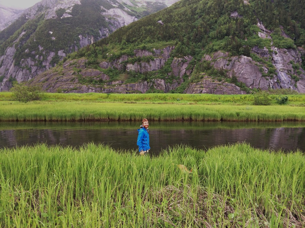
 Taking a GPS reading near corner #1 |
 Meadow flowers |
 A spiked timber! |
 I’m
not sure there is any place in the world more comfortable than my Taku
hammock
with a feather bed on top. So I managed to snooze and linger in bed
listening
to the intense rain drum on the roof until 8:45, after which I hustled
out of
bed, had a bite to eat, packed a backpack for the morning, and headed
to the
boat. My object: the eastern boundary markers on the property. The two
most
northern markers on that side of the property are at the base of the
cliffs on
the other side of T’awak Eix’i (Goose Slough), so I took the Ronquil
downstream
to its entrance. I touched bottom once going over the bar in front, but
was
soon able to see the bottom to look for rocks. I hugged the right
shoreline
hoping to find the timbers my parents had mentioned along that shore,
but came
up with nothing. I did find the prop-chewing rocks my dad had warned
about,
though—three of them on the left channel around the last big island
before the
slough narrows south of the big bend. Two were side by side and the
other in
the middle of the channel south of the others, close to the northern
terminus
of the island. I puttered around the bend and all the way to the
mountain where
the slough becomes unnavigable by boat due to rocks at the base of the
rock
slide and the narrowing of the channel. On the way I startled a few
ducks—probably mergansers.
I’m
not sure there is any place in the world more comfortable than my Taku
hammock
with a feather bed on top. So I managed to snooze and linger in bed
listening
to the intense rain drum on the roof until 8:45, after which I hustled
out of
bed, had a bite to eat, packed a backpack for the morning, and headed
to the
boat. My object: the eastern boundary markers on the property. The two
most
northern markers on that side of the property are at the base of the
cliffs on
the other side of T’awak Eix’i (Goose Slough), so I took the Ronquil
downstream
to its entrance. I touched bottom once going over the bar in front, but
was
soon able to see the bottom to look for rocks. I hugged the right
shoreline
hoping to find the timbers my parents had mentioned along that shore,
but came
up with nothing. I did find the prop-chewing rocks my dad had warned
about,
though—three of them on the left channel around the last big island
before the
slough narrows south of the big bend. Two were side by side and the
other in
the middle of the channel south of the others, close to the northern
terminus
of the island. I puttered around the bend and all the way to the
mountain where
the slough becomes unnavigable by boat due to rocks at the base of the
rock
slide and the narrowing of the channel. On the way I startled a few
ducks—probably mergansers.
 Just
shy of the rock slide I brought the Ronquil ashore, tied it to a
willow, and
set off along the mountainside looking for likely rocks. I knew from
survey
notes that the northeast corner would be on a boulder about five feet
high and
several feet around. Some of the rock face there has clumps of alder
shrouding
the base (and I found a couple of fairly mature birch trees, to my
surprise)
but I was pleased to find most of it was bare and easy to traverse, a
few pools
of water notwithstanding. It wasn’t long before I came upon a lone rock
sitting
about ten feet from the sheer, smooth cliff above, just begging to be a
rock of
note. Sure enough there was a boundary marker embedded in the rock
(unfortunately demolishing the original 1919 X engraved there) and an
aluminum
post with boundary marker signs was bent horizontal just in front. I
took a GPS
coordinate and photographs and perused the area for the pits and mounds
that
the 1919 surveyor had left behind, finding nothing noteworthy in the
marshy
meadow. It’s in such a wet area, in fact, that I wonder if it was drier
in his
day, as pits would quickly become pools of water. While I waited for
the GPS
locations to tick in, I looked under an overhang in the boulder where a
wasp’s
nest had broken off. Much to my surprise, I found partially intact
remains with
what looked like white dots. I didn’t stick around to investigate
further,
though, as a wasp was crawling around on it and I thought it prudent to
back
off.
Just
shy of the rock slide I brought the Ronquil ashore, tied it to a
willow, and
set off along the mountainside looking for likely rocks. I knew from
survey
notes that the northeast corner would be on a boulder about five feet
high and
several feet around. Some of the rock face there has clumps of alder
shrouding
the base (and I found a couple of fairly mature birch trees, to my
surprise)
but I was pleased to find most of it was bare and easy to traverse, a
few pools
of water notwithstanding. It wasn’t long before I came upon a lone rock
sitting
about ten feet from the sheer, smooth cliff above, just begging to be a
rock of
note. Sure enough there was a boundary marker embedded in the rock
(unfortunately demolishing the original 1919 X engraved there) and an
aluminum
post with boundary marker signs was bent horizontal just in front. I
took a GPS
coordinate and photographs and perused the area for the pits and mounds
that
the 1919 surveyor had left behind, finding nothing noteworthy in the
marshy
meadow. It’s in such a wet area, in fact, that I wonder if it was drier
in his
day, as pits would quickly become pools of water. While I waited for
the GPS
locations to tick in, I looked under an overhang in the boulder where a
wasp’s
nest had broken off. Much to my surprise, I found partially intact
remains with
what looked like white dots. I didn’t stick around to investigate
further,
though, as a wasp was crawling around on it and I thought it prudent to
back
off.
From
there I trekked to the big avalanche slide that is almost directly
behind the
cabin. Again from the survey notes I knew that the next marker was on
the north
side of the slide on a boulder about 1.5 feet tall and six or seven
feet in
diameter located about 50 feet from the rock wall. When I arrived
onsite,
however, I found that these directions were not entirely helpful.
Except for a
small opening near the corner of the slide, the whole area was covered
in dense
alders and bounders abounded. The mountain is so curvaceous there that
50 feet
was a wildly moving target. I started as far as seemed probable
(farther
actually) from the north end of the slide and tramped around in the
bushes to
no avail. Then I stepped up onto the edge of the avalanche itself— still
very
large and intact--and from there onto a boulder sticking about three
feet above
the snow, the northernmost in a series of large boulders protruding
from the
snow at the base of the slide.
still
very
large and intact--and from there onto a boulder sticking about three
feet above
the snow, the northernmost in a series of large boulders protruding
from the
snow at the base of the slide.
I scanned the area. And there, 30 feet in front of me, were the backs of Forest Service boundary signs, their post bent horizontal in the midst of a clump of alders. The post was right next to a rock of the right descriptions, but it was quite large and covered in a layer of damp leaves (it had continued to rain on and off all morning). Where on it was the marker? One or two sweeps with my hand and it appeared, close to the aluminum post and losing distinction in the creeping moss. I photographed it and the surrounding area, paced the distance to the rock, took a GPS location, and headed back to the boat, taking photographs along the way of more plants I wanted to identify back at home.
Before taking off I consulted my phone again for the plat and USGS map that show the property boundaries to determine the most likely place for the next marker, Corner #4. It was somewhere near the edge of the slough opposite the southern edge of the avalanche slide I’d just left. But there were no big rocks there, so I’d be looking for a marker in the meadow and so far that morning, none of the aluminum posts and signs I’d seen had been intact and the marker would be lost in the vegetation. I took my best guess and went ashore in an area where the bank ascended steeply to the edge of the meadow about six feet above the level of the slough. Clumps and individual willow trees grew up out of the grass and bundles of ferns lined the shore. I wandered the bank north until I was sure I’d gone too far, then doubled back a little farther from the water and repeated the process. Nowhere did I find any evidence of a marker. I did find a wonderful, cup shaped nest built in the fork of a willow about two feet off the ground, possibly the nest of one of the yellow warblers or Lincoln’s sparrows alarming at me from higher in the bushes.
I decided to head south and kept walking even past where I though the marker could possibly be, soon running into corner #5 where the property turns back toward the river. The aluminum post was there but there were no accompanying signs, nor did I see them on the ground nearby, just like the sign post at corner #1. Right next to it was the formal marker, perfectly intact and right at the edge of the bank in the middle of a soggy little runoff. After taking photos and a GPS location and noticing that it was directly across from the next fault in the cliff face, I headed back to the boat, pacing out the 171 meters that lay between the two corners. I wound up right in the middle of a clump of ferns where I’d previously expected it to be. But no matter how thoroughly I searched, I found no maker. Nevertheless, I was extremely pleased with the morning; my parents had never found corner #3 and I don’t believe I’d ever seen any of them before.
 Cailey
and I piled back aboard the Ronquil and headed down the slough. On the
way, a
fairly upright piece of wood caught my eye on the mountain side of the
river.
It was well upstream of where my mother thought the timbers I’d looked
for
earlier to be, but I decided to double check anyway. Sure enough, a few
feet
from the top of the steep bank, two upright 4x4 posts stood about ten
feet
apart. One was braced into the ground with another timber and the other
had a
heavy cable through the top of it that was anchored into the ground on
either
side, though the cable wasn’t taught. There were two 4x6 beams covered
in dead
grasses on the ground and an anchor that looked like a shovel handle
behind the
posts. Bears had used the posts for scratching, evidenced by kinky
brown hairs
high on both of them. Something had eaten or gnawed away part of the
northern
post as well. Puzzled, I took photos and left, only to turn back around
and
pick up a GPS location before returning to the cabin.
Cailey
and I piled back aboard the Ronquil and headed down the slough. On the
way, a
fairly upright piece of wood caught my eye on the mountain side of the
river.
It was well upstream of where my mother thought the timbers I’d looked
for
earlier to be, but I decided to double check anyway. Sure enough, a few
feet
from the top of the steep bank, two upright 4x4 posts stood about ten
feet
apart. One was braced into the ground with another timber and the other
had a
heavy cable through the top of it that was anchored into the ground on
either
side, though the cable wasn’t taught. There were two 4x6 beams covered
in dead
grasses on the ground and an anchor that looked like a shovel handle
behind the
posts. Bears had used the posts for scratching, evidenced by kinky
brown hairs
high on both of them. Something had eaten or gnawed away part of the
northern
post as well. Puzzled, I took photos and left, only to turn back around
and
pick up a GPS location before returning to the cabin.
After this four hour tramping adventure, I decided to take a break, so I had a cup of Russian tea and read on the couch. Cailey was ready for a rest as well and desperately wanted to come up on the couch with me. Despite a good toweling off, she was still soaking wet, so I was reluctant. She went upstairs and whined (I later decided she must have been plotting a strategy), then barreled downstairs and onto the couch before I could blink. She spread out between me and the couch and I allowed it, despite the dampness. She was shivering, so I tucked her under a blanket. She didn’t stop shivering for about half an hour.
When we were both suitably dry and rested, I decided to continue exploring the property line, this time starting from corner #6, the last corner and the southern corner on the river. I knew its location and the location of the next intermediary boundary marker not far to the west on the last spruce tree before the vegetation became dense alders. The 1990 survey cut a swath through the alders, so I had hoped to find some sign of it as an indication of the property line. I was unable to do so. There was absolutely no indication I could find of a disturbance in that mass of vegetation. I pushed through, surprised to find that it wasn’t very wide, and broke out into the meadows. I skirted around some peninsulas of willows and, in the middle of an immaculate stretch of grassy meadow, an upright post. It was another intermediary boundary, perfectly upright but as devoid of its signs as the others. From there it was an easy walk to the edge of the slough and corner #5.
From there I looked back at the post in the middle of the meadow and lined them up to a clump of willows toward the river—they stood out with a bluish tinge from the surrounding willows, so were easy to track once I placed survey tape on the meadow post and made my way back to the bushes. This was an intermediary clump, so I pushed through to a narrow meadow on the other side that bordered the alders. At that point I had no visual on the actual markers, so I guessed at the correct direction and soon plunged back into the alders. This time I chose a path that made use of some very smooth areas beneath the trees that were devoid of the usual clumps of devil’s club and other underbrush. Consequently, I came out somewhat south of the actual boundary. Once back at corner #6, I headed back out to the meadow, flagging the route with blue survey tape. I could line up the first two markers, so I used those to gauge my route, placing flagging every 10 feet or so, or closer if needed to see the next marker in the dense foliage. I kept looking behind me to line up at least two markers, preferably more, before placing the next one. Sometimes I had to backtrack and flag more trees as some tape soon disappeared into the leaves. Eventually I broke out in a soggy slough which curved right into the meadow; on my route was a dense clump of willows sticking out like a peninsula, so I decided to skirt it, then headed across the meadow and into the strip of trees beyond. On the other side of that, I could see the intermediate post, which I flagged, and used that to flag my best guess at the boundary between the strip of trees. Sure enough, it looked like it went right through that clump of willows back toward the river. Since I was sure no one wanted to tromp through it, I flagged around the outside of it, then filled in the last gaps at the edge of the alders and tromped back along my newly flagged line.
 While
I was finishing this task, a small plane landed on the river, which
meant that
Torsten had arrived. When I arrived at the cabin, he and his pilot
friend were in
the front yard enjoying the sunshine that was quickly replacing the
clouds. I
was sweltering in my raingear and grateful to take it off. After
lingering a
few minutes, we walked the pilot back to his plane (tied to a log just
upriver
from the dock) and anxiously watched him take off in the direction of
Taku
Glacier, right over the shadow of a sandbar (he had either
misunderstood or
ignored our direction to take off downriver along the bank).
While
I was finishing this task, a small plane landed on the river, which
meant that
Torsten had arrived. When I arrived at the cabin, he and his pilot
friend were in
the front yard enjoying the sunshine that was quickly replacing the
clouds. I
was sweltering in my raingear and grateful to take it off. After
lingering a
few minutes, we walked the pilot back to his plane (tied to a log just
upriver
from the dock) and anxiously watched him take off in the direction of
Taku
Glacier, right over the shadow of a sandbar (he had either
misunderstood or
ignored our direction to take off downriver along the bank).
Torsten and I explored around the marshy meadow upriver a little bit, then took a hot chocolate and peppermint schnapps break back at the cabin. It was still relatively early and the sun was out, so we then headed upriver for another excursion. At the boundary marker, Torsten climbed the cottonwood tree for a look around while I found a promising beep with the metal detector. I knew from the original 1919 survey notes that the boundary line in that area followed three wire barbed wire fencing. Sure enough, with one shovel I unearthed a strand, and then another a few inches beyond. From there we went looking for the intermediate marker along the property line that I’d stumbled onto years past, which I remembered being on the edge of the nearby slough. Torsten followed the barbed wire fence with the metal detector through the brush while I followed the easier route along the slough and soon found the post, also devoid of its signs. I flagged it and walked from there to the slough.
In the meantime, Torsten had found a little hillock where the metal detector was putting off some pretty serious tones. I’d left the spade back at corner #1, though, so it was hard to follow up. Torsten’s attention turned to the rock cliffs in the distance and their potential for climbing, so he decided to wade across the slough and check them out. I returned for the spade and did a little digging around the hillock, finding nothing. It quickly became apparent that the metal detector was malfunctioning, however, giving off a tone whenever it was in contact with the ground. When Torsten came back it was 8:30 and we called it a night. He cooked caribou tenderloin for dinner and we made some instant potato soup and feasted our success. Before we turned in we did some GIS work, plotting all the points we’d taken onto the USGS topo map we’d been working with.
 Walking along the cliff face |
 Boundary rock |
 Corner #2 |
 Corner #3 marker |
 Nest! |
 Near corner #5 |
 Corner #5 |
 Bear hair on the slough timbers |
 Boundary sign near corner #6 |
 Intermediary boundary sign between 5 & 6 |
 We find barbed wire |
 Original barbed wire fencing! |
 Torsten takes a bearing |
 Torsten crosses the creek to explore the cliffs |
 Caribou for dinner |
We did not sleep well. At 3:00 and 4:00, Cailey whined and paced enough that I was forced to get up and let her out. To my frustration, she just started eating grass; it looked to be stomach troubles. Unwilling to listen to her further, I closed the door at the top of the stairs and locked her out. It was another hour before I fell into a light slumber again, so I was not feeling very spunky when I struggled out of my hammock around 7:00. We had plans for the morning, and sleep would just have to wait.
Thankfully, I may have slogged through the Russian tea and granola bar I had for breakfast, but by the time we got to work, I forgot about my tiredness altogether. We jumped on the 4-wheeler and did a quick drive down the loop by the dock before picking up my backpack at the cabin and heading up the trail north to the meadows. We drove until we met an obstruction, then stopped and cut trees and branches until the 4-wheeler could make it. Our first stop was just shy of Debbie’s Meadow where Torsten cut a couple of young spruces with the Swede saw (though the whole trail to that point would benefit from trimming). From there we were in virgin territory for that machine. I had Torsten drive to see if he could follow the trail, which he did without a problem. We next stopped on the recreated trail I cut through the forest last year. When Torsten was cutting trees and limbs with the Swede saw I either waited on the 4-wheeler or went to town clearing limbs with clippers. The growth once again impressed me—everywhere this summer I feel oppressed by the manic press of vegetation. Towards the end of the trail I stayed behind to continue cutting while Torsten drove off to the next barrier. While I trimmed and trimmed and trimmed, I could hear him driving in the distance: he’d broken free and was out in the meadows.
When
he came back he was elated and demanded that I come check it out. We
breezed by
the property line and were soon flying through the meadows, crossing
the
sloughs with ease. Since we had the run of the Taku Road, we decided to
look
for my property closer to the lodge and so braved the lashing alder
branches
reaching into the road from what was once meadow, and eventually
crossed the
Bradley-Ogden Bridge and so won the forest. The road was not maintained
and we
crossed a couple of small fallen  trees--Torsten
sawed one off that
blocking the
route. I saw no sign of a marker on the side of the road, but we did
see a few
pieces of survey tape and eventually reached a 4-wheeler track on the
mountain
side of the road. I wondered if it was the road used by the lady I’d
met at the
historical library who told me she’d “opened up” her property there on
one edge
of the original homestead. We’d also passed cabin close to the road,
both of
which indicated we’d passed my property which is at the back corner of
the
homestead farthest from the lodge.
trees--Torsten
sawed one off that
blocking the
route. I saw no sign of a marker on the side of the road, but we did
see a few
pieces of survey tape and eventually reached a 4-wheeler track on the
mountain
side of the road. I wondered if it was the road used by the lady I’d
met at the
historical library who told me she’d “opened up” her property there on
one edge
of the original homestead. We’d also passed cabin close to the road,
both of
which indicated we’d passed my property which is at the back corner of
the
homestead farthest from the lodge.
We turned the 4-wheeler around and parked it, then walked down the road. All along the way we’d been using Torsten’s GPS app to map the route and, when I saw a road I recognized not much farther on, we decided to walk the rest of the road to map it, leaving the vehicle behind to be less conspicuous. Though I am always warmly met at the lodge, I didn’t feel much like meeting anyone at that moment, let along being obvious about the fact that a 4-wheeler had made it all the way from Bullard’s Landing. We wound up walking the waterfall trail backwards, then returned to the 4-wheeler and headed back. I drove this time and thoroughly enjoyed it. Poor Cailey loped or trotted along behind us, and must have been exhausted after her sleepless night; she hadn’t even had breakfast. Once we broke out into the meadows, she was able to lope along beside us so at least she wasn’t in the exhaust.
We made one small detour around the meadow on the way back, cut some small trees and branches at the property line to facilitate turning the 4-wheeler around, further trimmed some trees around the upriver start to the road, and then rode back on the improved trail. Much more comfortable, but still in need of a lot of trimming. Back at the cabin I made quesadillas for lunch, then hot chocolate for dessert, but we both fell asleep before we drank it.
I
rested for about an hour but didn’t sleep very much of it. Eventually I
roused
myself and did the dishes and cleaned up the cabin. By the time Torsten
got up
we were pretty much ready to go. He put the 4-wheeler back as he’d
found it, I
fueled the boat, we closed up, and took off downriver at 2:30, or an
hour and a
half before high tide. We touched bottom twice along the meadows below
the
slough, once going around the outside of the large root wad that is
stuck in
the channel and once below that. When we passed Scow Cove, I pointed
out the
cliff we’d walked beneath on our May camping trip and told him it
looked like
nice rock for climbing. He was dubious, but asked me to take him over
there
anyway. He would up enthusiastic about it and tested it in a few
places,
cutting a strange picture in his life jacket and hip waders clinging to
the
cliff. The rest of the trip was sunny and only slightly choppy here and
there,
and I came back to town full of my wild success.
 A beaver swims upriver |
 Torsten trims branches |
 A quick boulder at Scow Cove |
